Lake Superior Natural Area
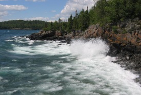
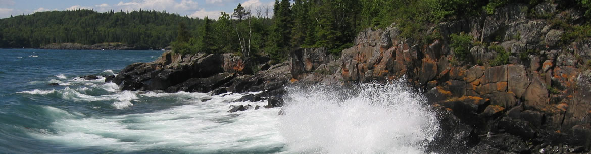
Waves crash on the northwestern Lake Superior Coast, Ontario (Photo by John Anderson)
The Lake Superior Natural Area is one of the Nature Conservancy of Canada’s (NCC) largest natural areas in Ontario, spanning from Sault Ste. Marie to west of Thunder Bay, and surrounding Lake Nipigon to the north.
Land Acknowledgement
The shorelines, vast cold waters and forested islands of the Gichigami (Lake Superior) watershed can feel otherworldly and isolated, but the water, islands and shores of Gichigami are the traditional lands of the Anishinaabe people.
The Nature Conservancy of Canada (NCC) recognizes the continued presence of Indigenous Peoples on and the nation/community’s contributions to conserving Gichigami. We thank the original and current stewards of the lands and water here.
NCC works with many Indigenous communities as partners in conservation to protect the plants and animals on the islands, small bays and peninsulas of Gichigami.
NCC recognizes the importance of these lands to Indigenous Peoples and we are dedicated to ensuring that the spirit of the land is honoured.
Current projects
Click here to learn more about our current projects in the Lake Superior Natural Area.

Lake Superior natural areas map. Click to enlarge.
Why this place is important
- Lake Superior is the largest freshwater lake in the world when measured by surface area.
- The coastlines and islands of Lake Superior are home to unique arctic/alpine disjunct plant species, such as common butterwort and encrusted saxifrage, which are normally found in higher latitudes and elevations.
- The Lake Superior basin contains vast tracts of coniferous and mixed forest, wetlands, barrens, cliffs and inland rivers and lakes, including Lake Nipigon (484,800 hectares).
- Lake Superior is the least impacted of all the Great Lakes and many of its aquatic habitats, watersheds and coast remains healthy and intact (State of the Great Lakes Report, 2022).
- Lake Superior and most of Canada were shaped by the power of the last ice age. Great sheets of ice over two kilometres thick covered the landscape, grinding the rock and depositing soils that today support the forests and wetlands.
- There is high conservation potential in the Lake Superior Natural Area. While disturbance is present across the landscape, there are tracts of land that remain a refuge for charismatic species like mMoose and feel like true wilderness to the people who visit them. With your help, we can continue to protect these important places and keep them wild.
- The northwestern shores of Lake Superior are a unique landscape and a key area for Great Lakes biodiversity. They are located within the Lake Superior National Marine Conservation Area.
What NCC is doing
- NCC has been protecting important parts of this natural area since 1999, with a focus on coastal and island properties.
- To date, over 9,000 hectares has been acquired for conservation.
- From Wilson Island near the Village of Rossport to the Big Trout Bay Nature Reserve on the coast south of Thunder Bay, important habitats have been conserved and are being stewarded according to the best available science.
- From the northwest to the southeast of Lake Superior, NCC and our partners are working to further conservation in this important natural area.
- Visitor infrastructure such as the James Duncan Nature Trail on the Big Trout Bay Nature Reserve have been established to provide an opportunity for the public to connect with nature.
- NCC has engaged other conservation organizations and volunteers in the stewardship such as trail construction and wetland rehabilitation.

What lives there
These are some of the significant and at-risk species found in this natural area:
Reptiles, amphibians and turtles
- snapping turtle
- Blanding's turtle
Birds
- Canada warbler
- Connecticut warbler
- peregrine falcon
- bald eagle
- bank swallow
- barn swallow
- bobolink
- chimney swift
- olive-sided flycatcher
- common nighthawk
- eastern meadowlark
- eastern whip-poor-will
- buff-breasted sandpiper
- eastern wood-pewee
- evening grosbeak
- golden eagle
- American white pelican
- short-eared owl
- rusty blackbird
- horned grebe
Fish
- lake trout
- brook trout
- American eel
- lake sturgeon
- northern brook lamprey
- shortjaw cisco
- silver lamprey
- kiyi
- deepwater sculpin
- blackfin cisco
Invertebrates (insects, arachnids, mussels and snails)
- northern dune tiger beetle
- Lake Huron grasshopper
- monarch butterfly
- transverse lady beetle
- West Virginia white
- yellow-banded bumble bee
Mammals
- tri-coloured bat
- little brown myotis
- northern myotis
- eastern small-footed myotis
- gray fox
- mountain lion (cougar)
- moose
- Canada lynx
- American black bear
- gray wolf
- woodland caribou once inhabited most of the natural area but today are struggling to persist on a few remote islands
Plants
- The forest of Lake Superior range from sugar maple- and yellow birch-dominated hardwood forest near Sault Ste. Marie to the boreal forests of the north shore with mix of black spruce, poplar, tamarack and white birch.
- false northwestern moonwort
- black ash
- branched bartonia
- dense blazing star
- Hill's thistle
- pale showy goldenroad
- pitcher's thistle
- lakeside daisy (observed within 40 km to the south, could be moving northward with climate change)
- Houghton's goldenrod (observed within 40 km to the south, could be moving northward with climate change)
Threats
-
Much of the Lake Superior watershed has been impacted by human activities such as logging, mining, housing and cottage development and road construction over the past 150 years. These activities continue today and have an impact on biodiversity.
-
Invasive species such as the common reed (also known as Phragmites) are changing the ecology of both inland waters and Lake Superior. NCC, along with its conservation partners, monitor and engage in control activities to address this and other invasives.
Partners
The conservation of Lake Superior Natural Area is not something we can achieve on our own. Only through strong partnerships can this unique area continue to grow and thrive. NCC would like to thank the following partners for their generous support of our ongoing efforts in this natural area:
- Pays Plat (Pawgwasheeng) First Nation
- Lakehead Region Conservation Authority
- Thunder Bay Field Naturalists
- Thunder Bay District Stewardship Council
- Ontario Parks
- Parks Canada
- Ministry of Natural Resources and Forestry
- Lake Superior Watershed Conservancy
- Thunder Bay Hiking Association
- Numerous dedicated volunteers who brave the black flies to help NCC take care of our nature reserves
Working with Indigenous communities
Pawgwasheeng (Pays Plat First Nation) has a strong cultural connection to Wilson Island and the Powder Islands. NCC and Pawgwasheeng have worked together to protect land and water in this area since 2009. Using western and Traditional Ecological Knowledge to establish how to best protect the area, the two groups have come together to ensure a future for the land and the species that depend on it for survival. Pays Plat First Nation stewards monitor the islands, share conservation messages with recreational users and maintain several campsites on the islands, while contributing to and consulting with NCC on how best to conserve the land.