Chaudière-Appalaches
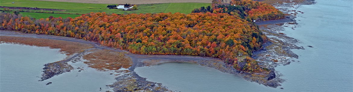
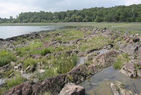
Jean-Paul-Riopelle Nature Reserve Trails (Isle-aux-Grues)
Jean-Paul-Riopelle Nature Reserve, QC (Photo by Claude Duchaîne)
Where nature meets culture
As you wander through the 2.5 kilometres of hiking trails on the reserve, discover the area's exceptional plants and animals. Find out how the area influenced the work of local artists. Jean-Paul Riopelle found much of his inspiration in this environment, which can be seen in his depiction of geese, owls and ferns and the explosions of colours in his paintings. Now it’s your turn to interpret nature through your own eyes.
Read more >
The site is open year-round for hiking and for snowshoeing in the winter. It is particularly impressive in the spring, with its many wildflowers and the arrival of a wealth of forest and aquatic bird species. It is located at the end of the chemin de la Haute-Ville, in Saint-Antoine-de-l’Isle-aux-Grues.
Access the island by a seasonal ferry service from Montmagny.
Click here to view the trail map.
Visit this Nature Destination
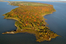
The upper marshes of Île aux Grues
Upper marsh viewing platform, QC (Photo by DanielTphoto)
In addition to protecting the Jean-Paul-Riopelle Nature Reserve, located on the western tip of Île aux Grues, NCC conserves the upper marshes on the east end of the island. This wetland is made up of a tidal flat (a strip of land) connecting the island to Île aux Oies that floods periodically with the tides. This site is an exceptional place for bird watching and observing diverse plants emblematic of the upper marshes.
Trails and viewing platforms await you at the end of Chemin du Roi, allowing visitors to take in the island’s picturesque scenery while protecting this fragile ecosystem. See the wonders of this habitat for yourself by watching these videos:
Île aux Grues: How you can explore the upper marshes
Île aux Grues: Shores of the St. Lawrence River
Île aux Grues: Country birds at risk
Île aux Grues: Agriculture then and now
Access the island by a seasonal ferry service from Montmagny.
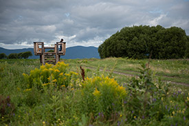
Méandre-de-la-Rivière-Vincelotte Nature Reserve Trail (Cap-Saint-Ignace)
An important aquatic ecosystem facing Île aux Grues
Méandre-de-la-Rivière-Vincelotte Nature Reserve, Cap-Saint-Ignace, Quebec (Photo by NCC)
Located 15 kilometres from Montmagny, facing the Île aux Grues island, the mouth of the Vincelotte River features vast biodiversity and is a vital aquatic ecosystem. Follow the 300-metre-long interpretive trail and explore the banks of the Saint Lawrence estuary and a pond visited by many species of waterfowl. If you have the time, take the Île aux Grues ferry and discover the Jean-Paul-Riopelle Nature Reserve — a 300-year-old maple grove (also a property of the Nature Conservancy of Canada).
This site is open year round, except during the hunting season (early September to end of november) for safety reasons.
Click here to view the trail map.
See below for directions.
Pointe de Saint-Vallier Trail (Saint-Vallier de Bellechasse)
Stroll along the shore near Quebec City
Pointe Saint-Vallier, Quebec (Photo by NCC)
Just 40 minutes east of the Quebec City bridge, discover a one-kilometre-long batture along the Bellechasse inlet. Stroll past fields and forests or see the shoreline from a kayak, where you can marvel at the incredibly diverse landscapes. In spring and fall, observe the greater snow goose and other bird species that stop here on their migration south. There are also many at-risk and native flower species in the freshwater estuary of the Saint Lawrence — flowers that don’t grow anywhere else in the world. Also, don’t miss the opportunity to visit the 18th century colonial manor located on the property.
The site is open to the public for visits in summer. Check out the programming of the Corporation du Domaine Pointe de Saint-Vallier for the schedule of organized activities. Costs may apply.
Help us protect nature
The exceptional nature of the site can only be observed if those who visit it take care of it. Please ensure you:
- leave your bike at the site entrance
- keep your pet leashed at all times
- stay on the marked trails (and avoid poison ivy)
- avoid picking any plants
- leave dead wood, stones, fruits and mushrooms where you found them
- refrain from feeding wild animals
- manage your and your pet’s waste
- respect the tranquillity of the premises, as well as the site's opening hours
Swimming, hunting and fishing are not permitted on the site.
Click here to view the trail map.
See below for directions.
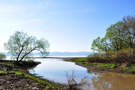
L’anse Ross (Saint-Nicolas)
Take a walk along the beach at low tide (waterfront access to the beach and river)
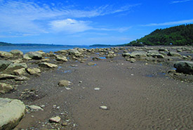
Anse-Ross, Saint-Nicolas, Quebec (Photo by NCC)
Enjoy this natural access point to the Saint Lawrence River, located on Quebec City’s south shore. Take a walk on the beach at L’anse Ross at low tide to enjoy a magnificent landscape notable for its sand, rocks and a bulrush marsh. The latter is welcome habitat for rare plants, including Parker’s pipewort, which is endangered in Quebec. This zone is also inside a waterfowl concentration area, so you may spot some bird species, especially during the migration season.
L’anse Ross is open to visitors during the summer season for low-impact activities: walking, swimming and non-motorized boating. Don’t forget to check the tide schedule by clicking here before your visit, as the beach is only accessible during low tide.
See below for directions.