Northern exposure
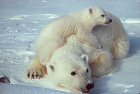
Polar bear mother with cub (Photo by Scott Schliebe/Wikimedia Commons)
By Allan Britnell, writer and editor
“The first time I ever saw a wild polar bear in the Arctic, it was passing by our remote field camp, several kilometres away on the sea ice,” says the Nature Conservancy of Canada’s (NCC’s) Christie Macdonald. At the time, Macdonald was working with a team from Environment Canada (now Environment and Climate Change Canada) collecting data on the migration and breeding habits of arctic birds.
The researchers watched the bear from afar through viewing scopes. “The bear didn’t seem to notice us. It was traveling in an environment that we consider to be cold and inhospitable, but here was a bear doing what the species had been doing for millennia,” she says. Macdonald had worked previously as a zookeeper at the Toronto Zoo, so she’d seen polar bears up close before, but never on their home turf.
“The encounter left me feeling invigorated and privileged to view this majestic creature in its home, and I wondered what it might see once it left our sheltered bay and headed up north across the open sea ice,” says NCC’s northern geographic information system (GIS) analyst.
Contemplating the vast landscapes of Canada’s north can be almost overwhelming. The arctic and boreal regions vary from coastal wetlands to permanently snow-capped mountains, with lichen-covered flatlands in between, and include many ecosystems that support species found nowhere else on Earth. But even in the most remote parts of the country, human activity has had an impact. From hydro dams and power line corridors, to mining and forestry, landscapes are altered and can become fragmented.
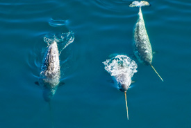
Narwhals (Photo by Mario Cyr)
In an effort to protect these landscapes and the species that live in them, the Nature Conservancy of Canada is joining forces with other conservation organizations, universities and local and indigenous governments to embark on an ambitious project: to produce a series of interactive, online nature atlases that will help create a clearer, more accessible picture of Canada’s north. The primary purpose of creating these maps is to provide the best-available information for future land-use planning. By 2021, the goal is to have at least nine nature atlases spanning the breadth of northern Canada.
Mapping the Big Land
NCC worked in partnership with the Environmental Policy Institute of Grenfell Campus – Memorial University of Newfoundland in Corner Brook, to create the first nature atlas, the Newfoundland and Labrador Nature Atlas (NLNA), which went live in December 2014 at nlnatureatlas.ca.
“We took a variety of information about the landscape — biological, physical, and human — and we gathered it in one place,” says Megan Lafferty, a conservation biologist with NCC in Newfoundland and Labrador. The NLNA currently consists of a series of 34 interactive maps, which cover topics ranging from types of land cover and the potential for mineral development, to the locations of conservation lands and sites with rare or endangered species and habitats.
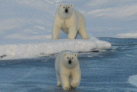
Polar bear mother and cub, Jones Sound, Nunavut (Photo by NCC)
Using the information available on the site, you can also create your own maps. “If you have a question, say, ‘How many polar bear sightings have been documented in Torngat Mountains National Park?’ you can generate a map that answers the question. And you don’t need in-depth GIS skills to do it,” says Lafferty.
“It’s a living document,” adds Macdonald. “As new information is collected, it can be uploaded and updated.”
Polar bears are known to roam for thousands of kilometres. When individual sightings are combined, it can help paint a better picture of the iconic species’ population trends, as they struggle to adapt to thinner and receding sea ice and other impacts of climate change. And local officials can better plan for development to minimize human–bear conflicts.
Already, the NLNA is assisting municipal governments, industries and other organizations in their land-use planning decisions. To make the information accessible to a diverse audience, the NLNA is available in English, Innu-aimun and Inutittut.
Pointing the way for conservation
Developing these nature atlases represents a shift in conservation strategies for NCC. Rather than securing private land acquisitions, NCC’s efforts in the north will be focussed on helping inform land-use planning.
“In southern Canada, it’s often straightforward to identify priority sites for conservation, whether it’s the best remnants of forests or grasslands, or endangered species habitat,” says Dan Kraus, NCC’s Weston conservation scientist. But in the north, it’s harder to pinpoint the most critical areas; and there are often multiple options for effective conservation.
“Canada has some of the last true wilderness areas left in the world,” says Kraus. “We have a huge responsibility to our children and grandchildren, and need to make sure our land use decisions are informed by good science and information.”
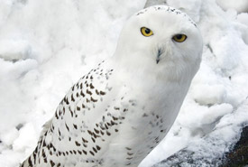
Snowy owl (Photo by Chris Moncrieff)
When people talk about getting a bird’s-eye view on a situation, they’re usually talking in the metaphoric sense. But on another trip Macdonald took, to Nunavut, at the northern tip of Hudson Bay, she had a breathtaking perspective while dangling from the side of a cliff to study breeding colonies of thick-billed murres.
“I felt extremely privileged to be at this beautiful site in such a breathtaking landscape,” says Macdonald. “To be sharing the experience with one-million birds and to be experiencing a place that has been used by local Inuit for egg and berry collecting for hundreds of years was very magical!”
The information Macdonald and others collect in the field will bring the important information collected by others in the field into the hands of decision-makers.
Best of all, for those of us who would rather leave the thrills and chills to others, these efforts to map northern biodiversity will help ensure these breathtaking places, and the plants and animals that live here, have a fighting chance at survival.
This story was written by Allan Britnell and originally appeared in the Winter 2017 issue of the Nature Conservancy of Canada Magazine. To learn more about how you can receive the magazine, click here.