Going paperless: Introducing a new data collection tool
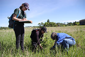
NCC intern and volunteers conducting a tree survey at Upper North Saskatchewan River Basin (Photo by NCC)
Over the past few years, the Nature Conservancy of Canada’s (NCC’s) Saskatchewan Region has used pen and paper to complete their rangeland health assessments. Rangeland health assessments are score-based sheets that are used to monitor the health and productivity of native grasslands. However, paper-based surveys have several problems, including collecting data in adverse weather conditions, slower data collection and spending office hours on data entry.
As the GIS intern for the Saskatchewan Region, I was given the project of converting the old paper-based health assessment sheets into a data collection survey for mobile devices. My goal was to create a survey that was almost identical to the paper-based sheet, but was user friendly and allowed for quick data collection.
From the many data collection services that the Environmental Systems Research Institute (ESRI) provides, I found that Survey123 Connect was best suited for our needs and would provide more efficient data collection, processing and analyzing. This is achieved by providing quality of life additions that would make data collection easier for the user and quality control measures that will be used to ensure data quality and accuracy of the rangeland health assessments.
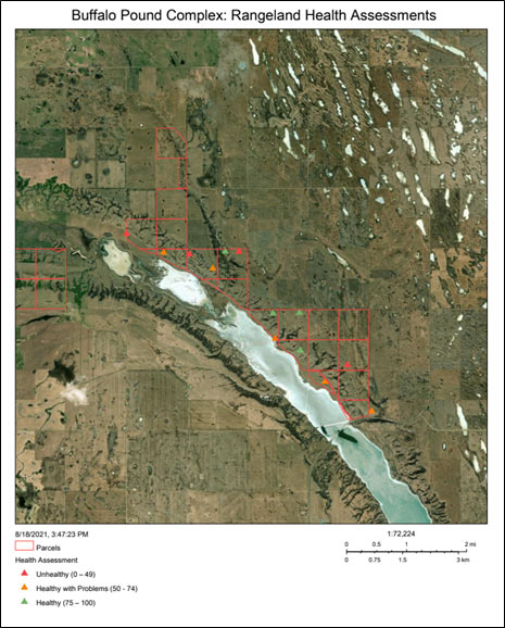
Web map of the Buffalo Pound Complex property 2021 rangeland health assessments conducted using the Survey123 Connect mobile survey (Map by NCC)
Some of the quality-of-life-additions include drop-down lists for properties, users and plant communities, auto-populating fields and auto-calculating fields. Quality control measures implemented into the survey include marking fields as required questions so that they are not accidentally skipped and numerical constraints on specific fields. Also, for questions that require multiple data entries within a single survey, such as recording multiple invasive plant species information, Survey123 Connect can provide that functionality.
Once a survey is completed by the stewardship staff, the data is automatically uploaded to ArcGIS Online, which eliminates unnecessary data entry work. The integration between Survey123 and ArcGIS Online allows NCC staff to view their data more effectively and to also generate maps easily through the use of web map applications. The built-in Survey123 reporting tool allow staff to present and organize their data in an efficient and clean manner, highlighting important information for decision making, such as which properties have the largest invasive plant species coverage and thus should be prioritized for weed removal.
Through completing this project, I am excited to further learn how mobile data collection applications, such as the one I created, can be used by the public or other conservation organizations across the country to help conserve and restore these beautiful lands.
About the Author
Matthew Hughes is a summer 2021 conservation intern for the Nature Conservancy of Canada's Saskatchewan Region.
