About the Hydrologically Significant Areas Project
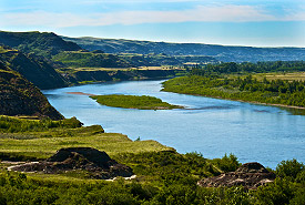
Red Deer River, Alberta (Photo by Karol Dabbs)
Watersheds, or regional drainage basins, are complex natural systems influenced by social, economic, cultural and ecological dimensions. When addressing land and water management, it is effective and logical to make decisions using a watershed perspective. The effect of development in one part of the system will impact the quality of the environment, both locally and downstream.
Increasingly, watershed partners are interested in land-use planning and development that supports not only socio-economic prosperity but also overall watershed health and resilience. Colleagues from across sectors are working to conserve and steward areas that provide hydrologic benefits, helping to mitigate floods and droughts while enhancing water quality.
When considering hydrologic benefits, there is a need to identify areas with natural assets that provide important hydrologic services, like water provision, flow regulation and water purification. Understanding the location of these areas — or hydrologically significant areas — can inform decision making on a variety of scales, whether it is a planner drafting a municipal plan or a land trust prioritizing potential project areas.
Since as early as 2015, the Alberta region of the Nature Conservancy of Canada (NCC) has been working on establishing a model to prioritize hydrologically significant areas (HSA). Partnering in a SAIT student capstone project, NCC was able to develop an HSA concept encompassing the Bow River watershed that captured the interest of the Southern Alberta Land Trust Society (SALTS). SALTS then worked with Associated Engineering to further develop the model and apply it to the Oldman River watershed. As interest grew, NCC facilitated model improvements and standardization across the Oldman, Bow and Red Deer River watersheds, in collaboration with the Red Deer River Watershed Alliance, the Bow River Basin Council, other land trusts, non-profit stewardship groups, government agencies, academic institutions and municipalities.
What is a hydrologically significant area?
We define HSAs as areas with natural assets that, if preserved in a natural state, provide beneficial hydrologic services, like water provision, flow regulation and water purification. An HSA is not a formal designation; instead, it is a term to help understand the importance of landscapes through the lens of water and aligns with watershed resilience thinking.
Why did the Nature Conservancy of Canada undertake this project?
The key objectives of the project were to:
- Evaluate and map natural assets that support healthy hydrologic functions on lands that will potentially be developed.
- Facilitate conservation actions for multiple user groups by identifying priority landscapes in their focal areas.
- Support a shared understanding, participation and partnerships in long-term planning across the watershed.
NCC undertook this work to support conservation planning and decision making, and to inform conversations within watersheds at various scales. The project was initiated with conservation in mind but partners across sectors are encouraged to use the information as a decision-making support tool to also inform development and stewardship.
Publicly available HSA maps are meant to help facilitate current and future conservation efforts by improving access to information that supports land use planning and decision-making. A map portal where HSA maps for the Red Deer, Bow and Oldman River watersheds is now available online and can be accessed through the links in this website.
When to use hydrologically significant area information?
The principal intended use for the HSA map is as a decision-support tool to inform land use, watershed and conservation planning. The high-resolution map can be used as a reference, in conjunction with other management tools for land evaluation, development planning, stewardship decision support and landowner engagement. Identifying areas that are important hydrologically is a crucial first step in ensuring that a landscape’s hydrologic value is considered in land use planning and development.
Examples of how the map output can be used to support decision making include:
- Identifying lands that land trusts may want to target for land conservation.
- Identifying lands that watershed or riparian stewardship groups may want to target for best management practices (for example, grazing and riparian health).
- Supporting municipal planning around watershed and headwaters health by identifying areas that need to be protected or may not be compatible with certain land uses.
- Supporting provincial planning around recreation and industrial activity on public lands.
- Identifying overlapping landscape values by comparing the maps to other datasets (e.g., important watershed features or wildlife habitats, range maps for species at risk, provincially designated Environmentally Significant Areas, Key Wildlife and Biodiversity Zones).
How were hydrologically significant areas created?
The HSA mapping tool was developed using a GIS spatial overlay model that incorporated relevant and representative landscape data. Six landscape inputs (layers) were created to identify areas that substantially contribute to hydrologic health. The inputs were derived from credible, open-source data that covered the extent of the watershed. A map output depicting HSAs was generated by overlaying the six inputs. By using a conservation-minded systematic approach, the intent was to create defensible, objective, repeatable and expandable results that can be modified as new inputs or updates become available.
Hydrologically Significant Areas Map Portal
NCC created a map portal where the HSA maps for the Red Deer, Bow and Oldman River watersheds can be viewed on the web. It was designed as a tool to help users better understand landscapes from a hydrological perspective, and to support decisions related to land use planning, development and conservation in a user-friendly format.
The map portal is an interactive interface that allows users to view HSAs in combination with either data that a user wishes to upload, or layers that are readily available in the platform.
Optional Layers
Geo-administrative, value-added and model input map layers are available to be used as a reference or aid in regional or local assessments. All layers have been grouped as boundaries, value-add layers and landscape inputs. Layers can be turned on and off, as needed.
The following geo-administrative boundaries are included in the portal:
- First Nations Communities
- protected areas
- cities, towns and villages
- rural municipalities
- treaty territories
- land-use framework regions
- Red Deer River Watershed Alliance sub-watersheds
- Hydrological Unit Code (HUC) boundaries: HUC2 to HUC10 sub-basins
- legal land descriptions for townships and sections
- Alberta green zones
The following value-added layers are included in the portal:
- Environmentally significant areas
- Annual recharge per acre (quantified for southern Alberta)
- Alberta natural sub-regions
Landscape inputs used in the development of the HSA GIS model were also included for the Bow and Red Deer River watersheds; however, NCC does not have access to the input layers from the Oldman River watershed project. The landscape inputs include:
- precipitation
- land cover
- slope
- surficial geology
- groundwater vulnerability
- water proximity
Reports
When using the HSA mapping portal, read the following reports that outline the process, assumptions, and datasets that went into completing the assessments for each watershed.
External funding partners
(Click on image below to expand)
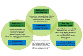
We would like to thank the following external partners for financially supporting our work in the Bow Watershed:
![]()
![]()
![]()
![]()
![]()
We would like to thank the following external partners for financially supporting our work in the Red Deer River Watershed:
![]()
![]()
![]()