Suzanne Marechal-Nature Conservancy of Canada, GIS Analyst
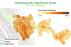
Hydrologically significant areas in the Bow River watershed
Hydrologically Significant Areas in the Bow Watershed
What is the problem you are looking to solve or the question you are looking to answer?
Precious water resources are being degraded over time, and water quality and quantity are being affected. As urban and rural centres grow, it is becoming more apparent that losses of natural habitats are linked to water quality and quantity degradation. By actively protecting natural landscapes that provide beneficial hydrologic services like water provision, flow regulation and purification, we can maintain and improve watershed resilience. This will result in healthier *riparian and aquatic habitats, cleaner drinking water and fewer floods and droughts.
With limited conservation funding, one challenge is identifying and prioritizing the landscapes that are most critical for healthy watersheds. The development of a publicly accessible web map that prioritizes hydrologically significant areas results in a decision support tool that can be used during conservation and land planning processes to highlight natural landscapes that, if left intact, support healthy hydrologic functions.
Can you give us a general description of the project?
To prioritize hydrologically significant areas (HSAs), we used a GIS (mapping) overlay process.
We first collected open source spatial datasets on a watershed scale to build landscape layers that would allow us to quantify the hydrologic services (water provision, flow regulation and purification) that are important for watershed health. Precipitation, proximity to water, soil infiltration, land cover, slope and erodibility layers were created.
We then scored the different features in each layer, with high scores given to landscapes that provided the most beneficial hydrologic functions.
Finally, the layers were overlaid and the scores multiplied together to create a final score. Mapping and classifying the final scores enabled us to visually prioritize hydrologically significant areas across a watershed.
What will you learn from your project?
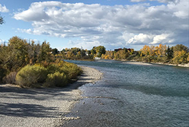
Early fall along the Bow River (Photo by Gayle Roodman/NCC staff)
Interaction with the map via a web portal enables us to visualize lands within areas of interest that, if protected and kept in a natural state, are key to building and maintaining the health of a watershed.
It also makes it easier to envision which regions within a watershed should be targeted for conservation or protected from development. The watershed scale map provides a common platform to facilitate collaborative planning with other stakeholders across watershed jurisdictions.
What is the biggest achievement of the project to date?
The two biggest achievements have been in outreach and development of a web-accessible decision support tool.
The initiative started in the Bow River Basin as part of a SAIT capstone project backed by the Nature Conservancy of Canada. Through the support of the Bow River Basin Council, the concept and results were presented to many organizations and watershed stakeholder groups. There was genuine interest in a tool that could evaluate land based on the hydrologic services it provides. As result, we have been able to fund and expand the project into the Oldman and Red Deer River Watersheds.
Through interactions with various groups and organizations, we recognized the need to get the information and tool into decision-makers’ hands. As a result, we developed a publicly available web-accessible map portal to provide municipalities, conservation organizations and watershed stewardship groups a platform to view results at a regional or watershed scale. There is also functionality to view supplementary data or add an organization’s proprietary information to help better inform decisions.
How can this project benefit NCC’s work and other conservation initiatives?
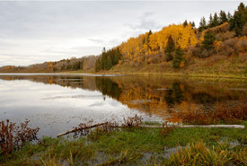
Bow River Watershed (Photo by Steven Ross/NCC)
The generated map assists conservation work in Alberta by helping to inform conservation and land use planning. The results can be used as a decision support tool in conjunction with an organization’s current resource management toolbox.
For example, a municipality or land trust can superimpose the HSA map onto an area of interest, along with municipal development plans or currently conserved areas. This helps visualize where a municipality may want to avoid developing or highlight a potential conservation corridor. It can also help to analyze data gaps or assess future conservation strategies.
What is your favourite part of the project you are working on?
Throughout the design and creation process, I enjoyed the challenge of using the mapping software to create an expandable, functional and user-friendly product. I was also inspired, as I worked with others, by their interest in the concept and the collaborative effort they made to support and enhance the outcome.
What gets you excited about the species/habitat your project is investigating?
I look forward to seeing this project encourage groups beyond land trusts to understand not only the environmental advantages but also the cost benefits of protecting natural landscapes that improve watershed resiliency.
With greater interest gained in conservation, the more support and funding there will be to protect important landscapes.
What is the impact you are hoping to achieve in Alberta (or beyond) with the project you are involved with?
My hope is that the HSA results will be accessible for anyone in the Oldman, Bow or Red Deer River Watersheds making decisions around land planning and conservation. Also, the map portal will help a wider variety of organizations to make decisions when protecting areas that area beneficial to maintaining healthy watersheds.
Is there a place where people who are interested in your project can go to learn more?
The map portal is currently in its final stages of development. If you are interested in the project or results, please contact Suzanne Marechal at suzanne.marechal@natureconservancy.ca.
We will be sure to let you know when the portal is publicly available and ready for use.