Pelee Island is for the birds
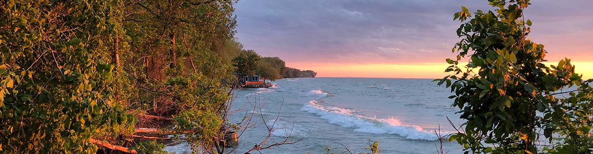
In the warm, green-blue waters of Lake Erie, Ontario’s Pelee Island is a haven for hundreds of species of migratory birds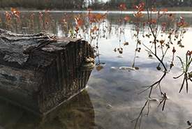
Restored wetland, Pelee Island, ON (Photo by NCC)
Situated in the relatively shallow, warm, green-blue waters of Lake Erie in Ontario is the 4,179-hectare (10,327-acre) Pelee Island. Mere kilometres from the U.S. border, Canada’s most southerly inhabited island shares a latitude with northern California and has a climate more similar to the Carolinas.
Pelee is the largest in a series of islands known as the Western Lake Erie Islands, which share a rich and vibrant natural and human history. From being outposts for rum runners and hosting Canada’s most southern winery, to providing habitat for many rare species at the far northern edge of their range, including the elusive gray fox, these islands have long attracted visitors from all over the globe.
Bird spot
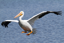
American white pelican (Photo by Bill Hubick)
While wine tasting and warm weather are always welcome, what people really come to Pelee Island for are the birds. Tens of thousands of them.
During the spring migration, hundreds of different species use the island as a refueling stop on their trip north. Once the weather begins to warm, the forested thickets and meadows are filled with the sounds of warblers — blackburnian, black-throated blue, palm, Cape May, black-and-white and American redstart, just to name a few. Egrets pick their way daintily through Pelee’s many wetlands. Huge flocks of swallows, including tree, barn, cliff, bank and northern rough-winged, dip and swerve through the sky. Bald eagles, American white pelicans, terns and gulls congregate along the shoreline.
A special place for conservation
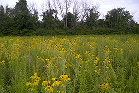
Recently restored field on Pelee Island, covered in grey-headed coneflower (Photo by NCC)
The Nature Conservancy of Canada (NCC) has been working to conserve this special place for almost 20 years. To date, NCC has protected over 390 hectares (1,000 acres) of globally rare shoreline, alvar and forest habitat, representing nearly 10 per cent of the island.
Several of NCC’s properties feature trails for visitors to explore and enjoy the sights and sounds of Pelee Island’s unique biodiversity, most notably the Florian Diamante Nature Reserve. The reserve has two trails, one 1.2 kilometres long, which winds through gray-head prairie coneflower, foxglove beardtongue and Canada wild rye-covered meadows. The trail travels around restored wetlands, providing views of shorebirds, ducks, herons and egrets. The 2.2-kilometre Noah Garno Trail takes visitors through
treed alvar habitat — a globally rare ecosystem of thin soil over limestone bedrock, which supports many specialized plants. The property also boasts trail signs and a parking lot.
The Florian Diamante Nature Reserve is home to important, ongoing stewardship work. Once partly farm fields, NCC is restoring this unique place back to its former glory, including creating a massive 25-hectare (62-acre) wetland, surrounded by native wildflower meadows. In the next few years we hope to expand trails, create more signage and install wildlife viewing blinds. This wetland will provide important nesting and feeding ground to Pelee’s migrant and resident bird populations.
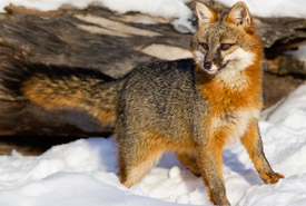
Gray fox (Photo by Ken Canning)
To date, NCC has restored 61 hectares (150 acres) on Pelee Island, and each year that number grows. But NCC cannot do all this work alone. Thanks to volunteers, supporters and the local community, NCC has been able to ensure that the birds of Pelee Island will continue to thrive and attract birders near and far.
Season
- Spring to fall (based on ferry dates)
Trails
Restored Field Trail (with parking lot)
- Type: hiking and biking
- Difficulty: easy
- Round trip distance: 2.4 km
- Surface: gravel and dirt
Noah Garno Trail (with trail signs)
- Type: hiking and biking
- Difficulty: easy
- Round trip distance: 4.4 km
- Surface: gravel and dirt
*note these trails do not connect.
Directions
Getting to Pelee Island
April-July: ferry leaves from Leamington (500 Erie St). August-December: ferry leaves from Kingsville (25 Dock Rd). Passengers are advised to book the ferry in advance if bringing a vehicle.
Check the weather and the ferry website before leaving, as inclement weather can cause delays or cancellations.
Getting to the Florian Diamante Nature Reserve trails
To get to the Restored Field Trail parking lot (coordinates 41.7978251, -82.6305191) from Pelee ferry terminal:
- From the ferry terminal, turn left/north on West Shore Road – 2.3 km
- Turn right onto West Pump Rd - 1.4 km
- Turn left onto Centre Dyke Rd – 150 m
- Turn right onto Parsons Rd – 3.1 km
- Turn left onto East Shore Rd. Destination will be on the left – 1.5 km
The Noah Garno trail is on the north side of Browns Rd (coordinates 41.8021935, -82.6411864). From the Restored Field Trail, turn left onto East Shore Rd, then left onto Browns Rd. Follow Browns Rd for 900 m and destination will be on the left, marked by trail signs.