Eyes in the skies
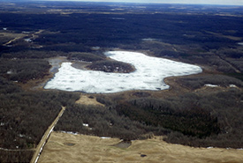
Coyote Lake Conservation Project in the Upper North Saskatchewan River Basin Focal Area during aerial monitoring April 2014 (Photo by NCC)
Our adventure began in late April at the small Cooking Lake Airport located on the west side of Cooking Lake, east of Edmonton. This airport falls within a Nature Conservancy of Canada’s (NCC’s) priority area: the Cooking Lake Moraine Natural Area.
On the eastern shore of the lake directly across from the airport is the Golden Ranches project, owned by NCC and our partners: Alberta Conservation Association, Alberta Fish and Game Association and Edmonton and Area Land Trust.
It was a sunny spring day and it was starting off on a good note. On the drive to the airport my colleague and I saw a moose, several hawks and the newly returned tree swallows perched on the fence. Our plan for the day was to fly over 20 NCC properties west of Edmonton in the Upper North Saskatchewan River Basin Natural Area. This included both conservation easements and NCC-owned lands.
This is our third year doing aerial monitoring in the Edmonton area, with great success. Our monitoring schedule is on a rotation with an aerial monitoring flight one year (with ground follow-up as required), and on-the-ground monitoring the following year.
Despite our best efforts, NCC staff members on the ground aren’t able to see every part of any given property, especially when dense woods, large wetlands and a large land base stand in your way. The best time of year for aerial monitoring near Edmonton is late fall and early spring. We have a short window of time when our view won’t be blocked by snow or big leafy trees.
While it’s a unique and beautiful experience to fly over the amazing land we conserve, it’s not for the faint of heart (or stomach!). Assessing the ground from 1,000 feet while flying in circles over a conservation project can have some adverse effects on your breakfast, as my colleague can testify to.
Back on the ground, the real work starts. First we sort through hundreds of photos and examine them closely for potential problem areas and for unique features (like bears and other wildlife). Then we create reports and follow up with landowners concerning conservation easements and planning stewardship for NCC-owned properties.
The knowledge we gain from our yearly aerial monitoring session allows us to have a birds-eye view of the entire property, and the landscape surrounding it. It allows us to focus our future ground level efforts on potential problem areas (trespassing by ATVs or missing trees for example), unique features and landscape level conservation actions. It also allows us to be efficient with our time, instead of spending 20 days surveying 20 properties. We were able to get 20 properties surveyed in one day and are able to spend more time increasing the conservation value of our properties.
About the Author
Jaimee Morozoff is the Nova Scotia program director for the Nature Conservancy of Canada.
