Googling the Earth like a pro: How NCC uses Google Earth mapping software for conservation planning
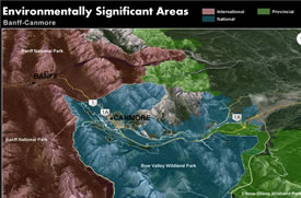
Environmentally Significant Areas near Banff and Canmore, AB (Map by NCC)
Web browsers who visit the Google Earth homepage are greeted with the friendly message "Hello, let's go explore."
But the web-based satellite mapping system is more than simply a fun way to explore our planet in three dimensions. It's also an important conservation tool.
The Alberta Region of the Nature Conservancy of Canada (NCC) has been harnessing the power of Google Earth in a variety of ways to assist our conservation work. Thanks to a donated License of Google Earth Pro through the Google Earth Outreach program, we in the Alberta Region have had access to extended software functionality. The Outreach Grants Program gives non-profit organizations the knowledge and resources they need to visualize their cause and tell their story in Google Earth & Maps.
Going Pro
The Pro License extends the power of Google Earth with additional capabilities, including GIS data import, Movie Maker, high-resolution printing and more.
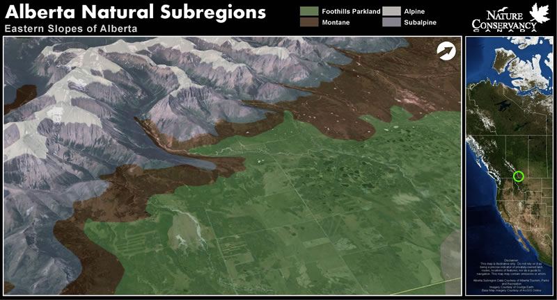
Google Earth-powered map of Alberta's Eastern Slopes (Map by NCC)
This ability to import pertinent spatial information, prepare maps and export high-resolution images for presentations and displays has made Google Earth Pro a valuable communication tool for NCC in Alberta. The three-dimensional capability of the Google Earth interface allows us to create oblique terrain maps that are both informative and visually appealing. These maps have allowed us to convey our conservation vision and challenges on the landscape in new ways with industry, government, donors and the public at large.
Mapping the value of the land
But that's not the only way that NCC's Alberta Region is using the functionality of Google Earth. We have developed a series of KML map files to help our staff interpret spatial information related to our conservation projects and natural areas. These interactive map files allow our staff to easily search for land parcels throughout Alberta and display various relevant spatial information such as natural area, ecozone and ecodistrict.
The KML map files also allows us to identify nearby Environmentally Significant Areas, existing parks and protected areas, internationally important wetland areas and areas of high ecological integrity as determined by our natural area conservation planning process.
This is all in addition to the already existing tools available in the Google Earth program such as measurement, historic imagery, elevation and coordinates. Having all of this information at our fingertips helps our conservation planners and coordinators to make strategic conservation decisions.
The exciting part is we're only scratching the surface of the many ways we can use Google Earth software in conservation planning, land management and outreach.