How do you solve a problem like migration?
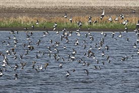
A flock of shorebirds takes to the air at Oak/Plum Lake Important Bird Area, a migration stopover site in Manitoba. The mixed-species flock includes Wilson’s phalaropes, red-necked phalaropes, stilt sandpipers, pectoral sandpipers, dunlin, white-rumped sandpipers and semipalmated sandpipers. (Photo by Christian Artuso)
I can feel the rapid thrumming of the bluebird’s heart against my palm as I carefully manoeuvre its foot into position over a tiny Ziploc bag. I pick up my nail scissors and take a deep breath to steady my hand. I will only get one chance to make sure the miniscule claw clipping lands in the bag. If it doesn’t, I will have no chance of finding it…and no way to discover where this bird spent the winter.
Field biology often requires unusual skills. I have spent the last decade becoming an experienced bird pedicurist. Analyzing the chemical composition of tissues like claws and feathers is one method scientists use to determine the movements of migratory animals.
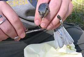
An ornithological pedicure: The author takes a claw clipping from a western bluebird for stable isotope analysis. (Photo by Catherine Dale)
Unfortunately, this method suffers from the same drawback as many others: a lack of precision. As a result, many aspects of bird migration remain a mystery. But this spring, researchers at the Max Planck Institute of Animal Behaviour in Germany are entering the final testing phase of a new space-based tracking system, which they hope will revolutionize our understanding of animal movement.
The puzzle of migration
For Canadians across the country, the return of our migratory birds marks the beginning of spring. Each year, 2.6 billion birds cross the Canada–U.S. border, heading north to their breeding grounds.
Two thousand years ago, Aristotle believed the spring reappearance of barn swallows meant they were emerging from their winter hibernation at the bottom of ponds. Although we now understand more about animal migration, many questions remain, largely because it’s very difficult to track individual animals, as they travel vast distances around the globe.
For many years, the only approach was to mark animals with bands or tags in the hopes of re-sighting them somewhere else. But the sheer number of animals that migrate makes seeing a marked individual again extremely unlikely.
Putting the pieces together
In the 1990s, migration research took a leap forward when scientists realized the chemical composition of animal tissue reflected the place where it was grown. By analyzing the ratio of various isotopes in tissue (termed stable isotope analysis), researchers can roughly reconstruct an animal’s geographic history, which is why I found myself giving bluebird pedicures.
Scientists can now track moving animals directly by fitting them with tags that record location. These tags can be divided into two broad categories. Archival tags, such as geolocators, record and store movement information. To find out where a tagged animal has been, researchers must recapture it and retrieve the tag.
Recapturing migratory animals often proves difficult, especially as many fail to return from migration. So when possible, researchers prefer to use tags that remotely transmit data to a receiver, eliminating the need to recover them.
But transmitting tags face a fundamental constraint: transmitting takes power, and the more power a tag requires, the larger it needs to be. Tags must weigh less than five per cent of an animal’s body weight to avoid affecting its behaviour or survival. Considering that many migratory birds weigh less than 10 grams, making tags small enough for them to carry is a huge challenge.
The amount of power required to transmit data depends largely on where the receivers are. Tags for ground-based tracking systems — with receivers located on the Earth’s surface — can be very small. For example, the nanotags used by the Motus Wildlife Tracking System range from 0.2 to 2.6 grams, and can even be carried by some large insects. However, the range over which ground-based systems can track individuals is limited. Animals carrying Motus tags can only be detected within approximately 15 kilometres of a receiver.
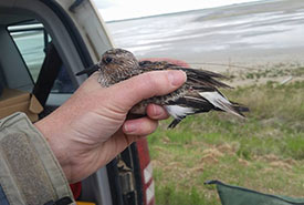
A sanderling carries a Motus nanotag. The tag’s long antenna is easily visible. (Photo by Jessica Howell)
In contrast, satellite tags send data to receivers on orbiting satellites. They can track movement at a much larger scale than ground-based systems, and have been used for years on big animals, such as seabirds and caribou. But most satellite tags are too heavy for small migratory birds.
The Icarus initiative
In 2007, Martin Wikelski, director of the Max Planck Institute of Animal Behaviour in Germany, proposed a novel space-based system for tracking animals across the globe.
It took more than 10 years, and the cooperation of the Russian Space Agency and the German Aerospace Centre, for the system to become a reality. In March 2020, the International Cooperation for Animal Research Using Space (Icarus) entered its final testing phase. The first Icarus tags are waiting to be shipped to researchers, and the system will be available to the scientific community this fall.
“We wanted to build [a tracking system] specifically for wildlife,” Martin says of Icarus. “It’s built by the community, for the community.”
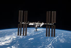
Icarus tags transmit their data to the International Space Station, pictured here in 2009 after a visit by the space shuttle Discovery to add additional solar panels. (Photo courtesy of STS-119 Shuttle Crew and NASA)
Icarus tackles the trade-off between tag size and transmission distance in part by the simple expedient of moving the receiver closer. Conventional satellite tags transmit their data to Argos satellites, which orbit the poles at an altitude of 850 kilometres. Icarus tags will transmit their data to a receiver on the International Space Station (ISS), orbiting at an average altitude of 400 kilometres.
Data collected by Icarus will be stored in Movebank, a free online database accessible by the public. The system will also incorporate a citizen science initiative: Animal Tracker. While Icarus tags tell scientists where an animal is, citizen scientists can provide information about what it’s doing there. Using the Animal Tracker app, people can follow tagged animals online, and anyone who spots those animals in the wild can submit their observations to the database.
Of course, like any tracking system, Icarus will have some limitations, at least initially. The first tags will weigh five grams, which — while smaller than many satellite tags — is still too heavy for most migratory birds. However, the design of a new generation of tags weighing only one gram is already underway.
Satellite coverage will also be an issue. The receiver on the ISS will be able to pick up signals from most of the Earth’s surface, but high latitude regions in the north and south will not be covered. Eventually, Martin’s goal is to deploy dedicated Icarus satellites strategically to cover the entire globe.
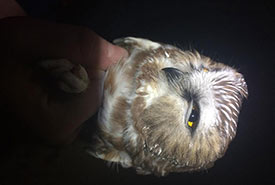
Banding a saw-whet owl. Kevin Fraser’s lab hopes to use Icarus tags to track these small owls during migration. (Photo by Kevin Fraser)
Even with these limitations, scientists are eager to begin harnessing the power of Icarus to tackle some of the unsolved mysteries of migration. Kevin Fraser, PhD, an assistant professor in the Department of Biological Sciences at the University of Manitoba is keenly awaiting his first shipment of tags. He and his graduate students plan to put them on saw-whet owls, and they are most interested in the birds that don’t come back in the spring.
Kevin’s previous research has largely depended on archival tags, meaning tagged birds must be recaptured to determine where they went. Individuals that don’t return to the study sites to breed — those that die along the way, or the young birds that disperse to breed elsewhere — are lost data.
“Most of what we know about migration, we know from birds that have successfully migrated,” Kevin says. “We know much less about where survival might be limited, or what the juveniles are doing. But [with Icarus], for the first time, we will be able to track 100 gram birds (the smallest yet) in near real-time, without the bias of only focusing on survivors and adults.”
Solving the puzzle
With the sliver of claw safely stowed in a bag for later analysis, I’m ready to liberate my captive bluebird. I position its feet over my empty hand and release my hold. For a moment, it perches on my palm, apparently unaware of its freedom…then, in a flutter of wings, it’s gone.
Of the 450 bird species found in Canada, 78 per cent spend at least part of the year outside our borders. This fall, four billion birds will cross our southern border to spend the winter in warmer climes. More than a billion of them will not return, succumbing to the dangers of the journey or the hazards of their wintering grounds.
Icarus offers us a unique window into the world of migratory birds and a chance to improve their odds. If we know where they go and how they get there, we can begin to understand the perils they face and perhaps develop solutions.
This article was written by Catherine Dale, blog editor and New Science Communicators Program manager at Science Borealis. It originally appeared on the Science Borealis blog. To read the full version of the article, click here.

About the Author
Catherine Dale Catherine Dale completed her PhD studying western bluebird migration in 2018, and now lives in St. John’s, Newfoundland, where she is coordinating the Newfoundland Breeding Bird Atlas for Birds Canada.
