What is GIS anyway?
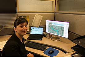
Sometimes Alayna Chan comes into the Nature Conservancy of Canada (NCC) office on a Thursday and sits down at her desk to work on data entry. (Photo by NCC)
Sometimes Alayna Chan comes into the Nature Conservancy of Canada (NCC) office on a Thursday and sits down at her desk to work on data entry. Sometimes she comes in on a Thursday and takes a truck out to do some bird banding in Saskatchewan’s Qu’Appelle region.
Alayna is NCC Saskatchewan Region’s GIS intern this summer. The GIS intern position is an interesting blend of field work and office work, which is perfect for her. She is studying environment and society with a minor in geomatics (which, according to Alayna, has something to do with geography. This English major just took her word for it) at the University of Saskatchewan.
When I first met Alayna this summer, I was wondering what you may be wondering now: What does GIS mean? I’ll leave the explanation to her: “Anytime you use Google Maps, you are using GIS! GIS stands for geographic information systems. It involves using mapping software for creating spatial data visualization (making maps), and it has powerful tools for spatial analysis. GIS can be as simple as mapping out where roads are on a map or providing directions to the nearest grocery store. It can also involve statistical analyses, like estimating rainfall for areas without weather stations or determining which area of a habitat is most at risk from factors like climate change, mining or even naturally occurring factors.”
Related blog posts
Alayna describes the spatial data that GIS uses as tied to a location. “Let’s say the colour of your house is pink. Your neighbour’s house is blue. This is a type of data. We have two houses, 50 per cent blue, 50 per cent pink. But these two houses could be anywhere. Are they in Canada? Australia? This data is not tied to any specific location. Now, let’s give the houses addresses. The pink house is at 123 Dreamhouse Drive in Regina, Saskatchewan, and the blue house is at 125 Dreamhouse Drive. Now it has become spatial data, because we have the specific location of these two houses. This is the kind of data we use in GIS. Location is usually defined in terms of geographic coordinates, like latitude and longitude, or Universal Transverse Mercator system coordinates.”
Alayna also notes that GIS can use aerial imagery, satellite imagery or laser sensors to collect spatial information tied to GPS coordinates.
About the nature of her job, Alayna says, “I don’t sit at a desk all day. I’ve been able to help out with field work as well, including property monitoring, vegetation health assessments and bird banding. I’ve also been learning and practising plant and bird identification skills. This past week, I spent four out of five days out of the office, doing field work!”
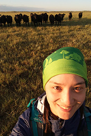
Alayna out in the field at Old Man on His Back Prairie and Heritage Conservation Area, SK (Photo by NCC)
Alayna describes working with master vegetation shapefiles as “standardizing the vegetation entries for NCC’s properties in land information systems (LIS), so that they have the same type of information stored in the correct place in the database.” She says her work should make it easier for anyone at NCC currently using LIS to find what they are looking for.
On large properties, Alayna explains, the vegetation data is used to monitor the different vegetation communities that exist there. “Knowing the location and number of different vegetation communities helps make monitoring more efficient,” she says. “Vegetation communities are also important indicators of habitat and can help determine likely locations for species at risk.” Her time spent at her desk is just as important as her time in the field to the conservation work NCC does.
One of Alayna’s favourite parts of her job is being the bridge between the office and our properties: “I love the field work aspect. It makes the data I am working with feel so much more tangible. I work with the data for a property and also get to see what that property actually looks like.”
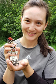
Alayna banding a yellow-bellied sapsucker (Photo by NCC)
Another favourite is bird research in the field, including bird banding and counting baby birds in nest boxes with her supervisor, Sarah Ludlow, NCC's conservation science and GIS coordinator in Saskatchewan. Alayna describes the field work as experiential learning, even if sometimes that experience is just learning that tree swallows are territorial because they are diving at her head every time she gets near a nest box!
After graduation, Alayna is interested in continuing to work in conservation. “As my current internship has shown me, there are many applications for GIS in conservation work, and I look forward to exploring more of its potential applications to conservation in the future.”
As the custodian of Saskatchewan’s cadastral data, the Information Services Corporation (ISC) is proud to partner with the Nature Conservancy of Canada as sponsor of the GIS intern position, with funding as well as surface cadastral data to support this valuable learning opportunity.
The Conservation Internship Program is funded in part by the Government of Canada's Summer Work Experience program.
About the Author
Maia Herriot was the summer 2019 communications intern for NCC's Saskatchewan Region.
