Whitebark pine research in the Darkwoods Conservation Area
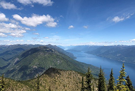
The view from the top of Mt. McGregor capturing some of the remote and wild terrain within the Darkwoods Conservation Area. (Photo by Stephanie Jouvet)
The rugged beauty of the Purcell and Selkirk mountain ranges extend far into the distance, as I follow the calmness of Kootenay Lake from its northern reaches, south to where it fades into the marshlands of the Creston Valley Wildlife Management Area. I’m standing at the peak of Mt. McGregor, soaking in the views while admiring all the wilderness that surrounds me. And I can’t help but feel grateful for the opportunity that brought me to this captivating place.
I’m currently taking the Geographic Information Systems (GIS) undergraduate degree at Selkirk College. The program is designed to foster the ability and technical skills to collect, manage and analyze spatial data across many industries. I also work as a student researcher for the Selkirk Geospatial Research Centre (SGRC), where they focus on using geospatial technologies to solve current environmental and socio-economic issues.
My supervisor at the SGRC, professor Brendan Wilson, is a well-respected biologist and chair of the School of Environment and Geomatics at Selkirk College. Brendan teamed up with Adrian Leslie, the West Kootenay project manager for the Nature Conservancy of Canada (NCC), to help execute a whitebark pine research project within the Darkwoods Conservation Area.
Adrian has over 15 years of experience in terrestrial ecosystem research and restoration, and he happens to be a former student of Brendan’s. Luckily for me, I was given the opportunity to team up with both professionals and conduct my undergraduate thesis research on the whitebark pine project at Darkwoods.
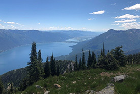
Darkwoods Conservation Area, BC (Photo by Stephanie Jouvet)
The scoop about Darkwoods
Darkwoods is privately owned and operated by NCC. It is located in the West Kootenays of British Columbia, nestled between Nelson and Creston. Its 63,000 hectares (over 155,600 acres) consist of complex and remote terrain of valleys, mountains, lakes, creeks and diverse forests. They provide important habitat to many different plant and animal species, including some that are listed as threatened or endangered by Canada’s Species At Risk Act.
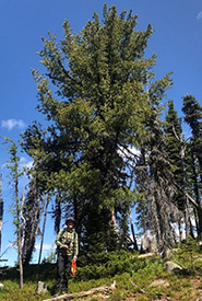
Brendan Wilson standing with an old growth whitebark pine tree at the Mt. McGregor site in the Darkwoods Conservation Area. (Photo by Stephanie Jouvet)
All about whitebark pine
To better understand the objectives of my thesis, it’s important that I touch on a critical component. Whitebark pine is s integral to high-elevation ecosystems in western North America. It’s considered a keystone species, for the many ecological benefits it provides, including its high-quality food source that many wildlife species rely on.
In Canada, whitebark pine is federally listed as endangered under the Species at Risk Act. Its numbers are rapidly declining due to the impacts of white pine blister rust, mountain pine beetle, fire suppression and climate change. Extensive recovery strategies have been implemented, by organizations all over North America, in efforts to mitigate those impacts as well as determine the species distribution across the landscape. Understanding the full extent of whitebark pine occurrence can provide resource managers the information that can be used to create effective localized recovery strategies at a patch or stand level.
Identifying whitebark pine from the sky
Remote sensing has become an integral tool used by forest managers. It streamlines traditional field-based data collection by reducing the time and resources needed to map detailed forest information over large areas.
My thesis focuses on using remote sensing methods and techniques to distinguish whitebark pine from other subalpine species within diverse forest environments. The aim is to explore the spectral characteristics (the wavelength reflectance or emittance of needles/leaves) of each tree species of interest and identify any discerning features that can be used to identify the species. Using the spectral information derived, and additional ancillary data, a whitebark pine distribution model will be generated to create a map that illustrates the probability of whitebark pine occurrence for the Darkwoods area. This model will ideally uncover whitebark pine populations that haven’t been previously identified, therefore, allowing for the health of those trees to be assessed and the best localized treatments to be applied if necessary.
What's next for this study?
The reference data was collected from two high elevation sites — Mt. Burnett and Mt. McGregor. Both sites have breathtakingly beautiful mountains with epic views and provide habitat for many old-growth and new-generation whitebark pine trees. I feel extremely fortunate to have spent a number of days exploring this remote and wild place. Although the research is still in the preliminary stages, I’m optimistic that our efforts will contribute to conserving the foundational whitebark pine species within the Darkwoods Conservation Area.

About the Author
Stephanie Jouvet is a student at Selkirk College taking the Geographic Information Systems undergraduate degree.
