A glimpse of the past: Using historic maps to guide land management
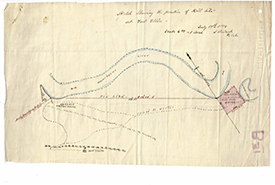
Historic land survey outlining the store house and fort site at NCC’s Fort Ellice property in MB (Photo by Manitoba Archives 2019)
The Prairie provinces, like much of agricultural Canada, look vastly different than they did before European settlement. During the development of Western Canada, forests were cleared, wetlands drained and grasslands plowed in an effort to settle...
Are you seeing the whole picture? Using elevation data to help conserve biodiversity
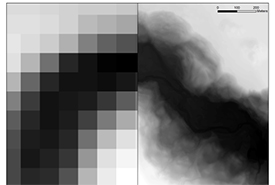
Elevation data showing the Beaver Creek River Valley. Historic data (100-metre resolution) vs. newly available LiDAR data (> one-metre resolution). (Image by NCC)
As a land planner, I am always looking for new ways to learn more about the landscapes in which the Nature Conservancy of Canada (NCC) works. Enter LiDAR (or light detection and ranging), a technology that has been around for decades but...
