One million steps: A hike to honour the legacy of conservation (Part two)
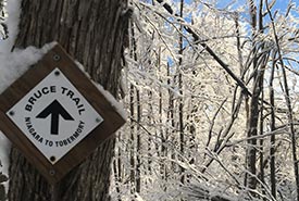
Snow-covered trail sign at Hockley Valley, ON (Photo by Dan Kraus/NCC staff)
Hiking north, we crossed the height of land that defines the watershed between Lake Ontario and Lake Huron. This landscape includes Hockley Valley and Mono Cliffs, provincial parks I had only rarely visited in the past. Over a century ago, much of this landscape had been cleared by the first settlers. But they discovered that the rolling hills and sandy soils were unsuitable for growing crops. Much of this marginal land had been reforested in arguably one of the largest ecosystem restoration projects in Ontario’s history. Walking through pine plantations and maturing forests of maple and ash, we felt the temperatures drop, and it snowed. What we thought would be the last winter storm, turned out to be our first.
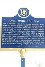
Following the trail to some of the same places John Muir visited in Grey County over 150 years ago. (Photo by Dan Kraus/NCC staff)
In Grey County we followed in the footsteps of John Muir, one of the founders of national parks in the United States. John Muir lived in Meaford from 1864 to 1866, where he explored the escarpment. With a blanket of snow across the landscape, I realized my hopes of botanizing the places Muir visited over 150 years ago were not going to happen. A few evergreen ferns poked through the snow on cliffs and boulders. On a property near Bognor that NCC helped to protect in 1977, we found several clumps of the globally rare American Hart’s-tongue fern.
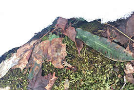
Hart's tongue fern (Photo by Dan Kraus/NCC staff)
The snow continued to fall. Instead of chasing spring, it now felt as if we were fleeing winter. When a large storm with snow and freezing rain was forecast for Owen Sound, we knew our only option was to mimic what we had seen songbirds doing during previous storms — hunker down and get out of the weather.
Into the Bighead River valley with an ice storm approaching our way (Photo by Chris Knaggs)
After three stormy days, we picked up the trail north of Wiarton near the base of the Bruce Peninsula. We were disappointed to have missed a section of the trail, but were excited to be at the gateway of the one of the last wild areas of southern Ontario.
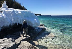
Witnessing the process of waves and ice that keep the forest canopy open along parts of the Great Lakes coast at Bruce Peninsula (Photo by Chris)
The wildness of the Bruce Peninsula landscape was punctuated by the weather. The snow storm had left its mark further north than we expected. With the trail obscured by snow, and our packs stuffed full with provisions for the final five days, our steps were deep and slow. I experienced the most trying hike of my life. Step…step…step. Not spring, but the winter landscape revealed secrets and beauty. River otter slides down steep slopes to Lake Huron, turquoise waters mixed with ice and trees along the coast bowing to the lake, encased in clear ice that would not melt until warmer days.
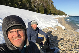
Chris and Dan hanging out along the shore of the Bruce Peninsula (Photo by Chris)
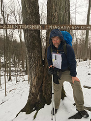
On April 21, we made it to Tobermory. After five days of wet feet, deep snow and freezing temperatures, I wasn’t sure I had many steps left in me. Snow, falling branches after ice storms and trail closures forced us to bypass parts of the trail, but after 28 days, we had covered over 800 kilometres on the trail and taken over one million steps.
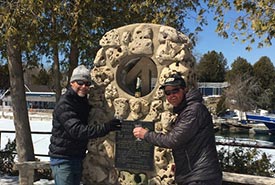
At the Bruce Trail's northern terminus. A toast to a journey well travelled. (Photo by Ann Kraus)
Our hike took us through hundreds of properties that have been protected by government, conservation groups and individuals over the last 100 years. Conservation lands that had been supported by thousands of people who wanted nature to be their legacy to future generations. Some were protected quickly and easily. Some required years of persistence and patience. Some were lost. Each of these properties is important for the species and habitats it protects — but the greatest legacy is the sum of these sites. Protecting the Niagara Escarpment shows the best of what we can do for nature. A living green corridor that links wildlife habitats, that protects water and cleans air, and that helps connect people with the natural world.
On the Niagara Escarpment and throughout our country, there is still much work for our generation to build on the conservation legacy of Canadians before us. Conservation is joyful and invigorating, and it can also be a trying and arduous journey. I want my children and their children to have a Canada where nature is part of their lives, where nature is valued, and where nature is protected.
We’re not there yet. But with each step we are getting closer.
For more photos chronicling the Legacy Land Hike, follow my Twitter hashtag #LegacyLandHike.
About the Author
Dan Kraus is the director of national conservation for the Wildlife Conservation Society Canada.
